×
Each hour forecast is assigned one of these 3 colors:
Click an hour to view more details about the forecast for that timeframe - this will open a matrix of info boxes.
Some boxes will have the icon, which means, you can click those to learn even more.

Kp Index forecast is provided by GFZ and NOAA
Satellites, in-flight wind and gusts, and nearby pilots forecast data are provided by
Accurate Drone Forecast
Q. How do I use OK TO FLY?
To determine if it's OK to Fly, we break down each day by the hour.Each hour forecast is assigned one of these 3 colors:
| Good to fly - no issues in the forecast |
| Pay attention, risk is elevated |
| High risk, be sure to verify conditions |
Click an hour to view more details about the forecast for that timeframe - this will open a matrix of info boxes.
Some boxes will have the
Q. What are 'Sats' and how is the satellite forecast so accurate?
Satellites ('Sats' in short - GPS and GLONASS) allow the drone to find its exact location, and help it fly home if needed. Satellite reception is critical for safe drone flying, especially when flying in areas with hills or mountains. Satellites orbit the earth constantly and their position in the sky keeps changing.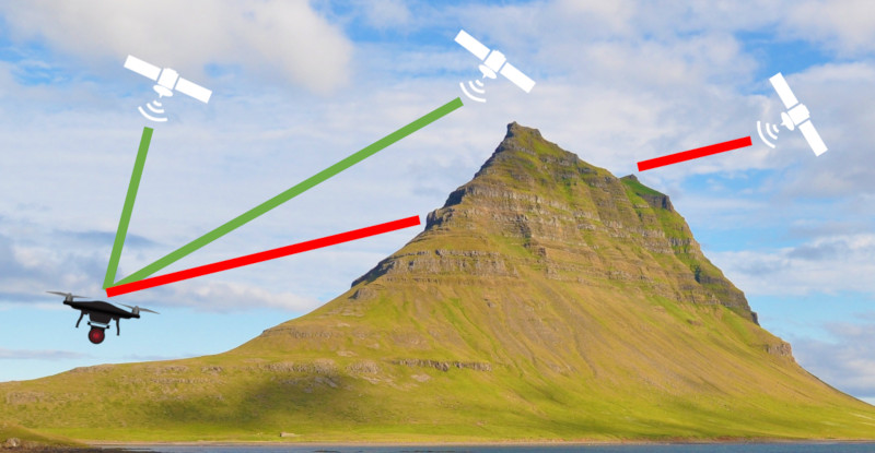 |
For each hourly forecast, we calculate the position of each satellite relative to your location, and check the ground elevations around you, to determine if those satellites are hidden or blocked in your location. Based on that high-resolution actual ground elevation data, we are also able to determine the forecasted satellite count at different heights above the take-off location - helping you plan the flight properly. In real time we test thousands of elevation points for each forecast hour, so we can accurately predict safe GPS conditions. For a full 15-day forecast, we evaluate over a million elevation points around your location! Our satellite forecast is accurate to +/- 1 satellite over 90% of the time. |
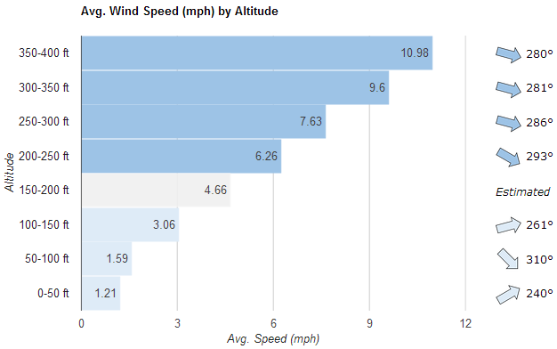
Q. How do you forecast the wind at different heights?
|
Using 3D aerodynamic models of each aircraft type, Airdata UAV
provides high-res Inflight wind data at different heights
(read more about this
here).
Using the wind data from millions of flights in 220 countries, we developed an artificial intelligence algorithm that can accurately
predict wind at different heights.
Clicking the |
 |
Q. What are "Pilots Nearby" and "Pilots Planned"?
The pilot count is based on other users who are currently using OK to FLY services. The count of "Pilots Nearby" is shown under the current forecast ("NOW"), whereas "Pilots Planned" is shown for all future time slots. We are currently working on the ability to provide pilots a "check-in" option to let others know you will be flying in the area.Q. What is the Kp index?
The Kp Index measures geomagnetic disruption caused by solar activity around the world, on a scale from 0 (calm) to 9 (major storm). The higher the Kp index, the more likely the drone is to have problems.| Quiet | Unsettled | Active | Stormy | Major Storm |
| Kp of 0 - 4 | Generally safe |
| Kp of 4 - 6 | May experience minor GPS issues |
| Kp of 6 - 7 | May lose a single satellite lock and may cause inaccurate location readings, radio/control interference possible |
| Kp of 7+ | Unsafe. You may lose multiple satellite locks. Higher chance of inaccurate location readings, severe radio range impact, and onboard electronics interference |
Q. What is "Precip Prob"?
This is the probability of any kind of precipitation, including rain, snow, hail, or sleet.Credits
On-ground weather forecast is provided by
Kp Index forecast is provided by GFZ and NOAA
Satellites, in-flight wind and gusts, and nearby pilots forecast data are provided by
Want to see an extended forecast?
Register to Airdata, it's FREE!
No credit card required
Please login or register to get access
Want to see a 15-day forecast?
Upgrade now!
Paid Airdata subscribers
can view a 15-day forecast
This site is operated by Airdata UAV.
By using oktofly.com, you accept the Airdata UAV:
Terms of Use
Privacy Policy
By using oktofly.com, you accept the Airdata UAV: